GÉOMTL


An event that brings together all people
passionate about geospatial technologies
October 8 and 9, 2025
Centre des congrès de Saint-Hyacinthe
The 22nd event hosted by CIG Montréal provides the spark for new opportunities in geomatics
Sponsors and Exhibitors
Main
Since 1995, K2 Geospatial has been dedicated to democratizing access to information and spatial analysis tools by developing innovative software solutions. These solutions provide effective visual aids to decision-makers by facilitating the connection, consolidation, and publication of data often scattered across different systems. K2 Geospatial thus enables employees and citizens to easily access information, perform real-time analyses, and make informed decisions.
K2 Geospatial’s software simplifies access to both spatial and non-spatial data, as well as to analytical tools, improving decision-making and generating optimal results. The solutions offered integrate and connect various systems, data sources, and technologies within organizations, creating an integrated, non-intrusive, and secure environment. This integration removes the challenges usually associated with linking siloed environments and independent systems.
The consolidated data is presented through an intuitive mapping interface, providing a clear and detailed overview. This real-time insight helps users streamline crucial decision-making and optimize their operations.
Silver

For over 22 years, Groupe Trifide has been transforming complex geospatial data into certainty for its clients. Our mission is to provide reliable solutions by mastering the entire value chain: from drone and mobile mapping acquisition to the rigorous processing and certification of data.
This integrated approach guarantees the highest quality deliverables that are ready to be leveraged. To facilitate access, our proprietary Trifide|360 platform offers intuitive visualization and measurement tools.
By building lasting partnerships, we are committed to developing custom solutions that meet our clients' objectives. The trust of nearly 500 municipal organizations and over 2,000 clients is a testament to our expertise.

Founded in 2004, XEOS Imaging Inc. specialized in aerial photography of strategic corridors such as pipelines, power lines, and roads.
Between 2015 and 2024, the company integrated cutting-edge lidar systems, including the Riegl VQ-1460 (4.4 MHz), a first in North America.
Since 2018, XEOS has developed AI tools to automate the processing of lidar point clouds, becoming the first company in the world to achieve precision mapping using AI, with patents filed in Canada, the United States, Europe, and Australia.
Its expertise, advanced technologies, and the stability of its team, with several members onboard for over six years, ensure unmatched service quality for its clients.
Bronze
Isogeo offers a SaaS platform that automates the creation and maintenance of your geospatial data catalog. Quickly access the data you need, use it directly in your GIS tools, and share your catalogs with your teams or online.
Designed for GIS professionals, our solution supports industry-standard formats, norms, and protocols, and integrates seamlessly into your technical environment.
Founded in 2009 and based in Paris, Isogeo works with over 60 organizations across France and Québec.

Esri Canada provides geographic information system (GIS) solutions that empower people in business, government and education to make informed and timely decisions by leveraging the power of mapping and spatial analytics. These solutions enable organizations to better manage their resources, plan their future and collaborate within and beyond their organization. Esri Canada’s products and services help advance successful digital transformation. The company serves 12,000 organizations from 16 offices across Canada and is based in Toronto.
Jakarto specializes in high-precision 3D mapping, capturing and processing geospatial data to create detailed digital twins of cities. Our technology empowers municipalities and businesses to better manage infrastructure, optimize urban planning, and enhance environmental resilience.
Powered by AI-driven automation, Jakarto extracts and analyzes urban inventories—trees, roads, buildings, signage, and more—streamlining decision-making for smarter city management. Our interactive web platform provides seamless access to critical data, enabling cities to plan, visualize, and manage their territory with precision and efficiency.

Stantec is a global leader in sustainable engineering, architecture, and environmental consulting. The diverse perspectives of our partners and interested parties drive us to think beyond what’s previously been done on critical issues like climate change, digital transformation, and future-proofing our cities and infrastructure. We innovate at the intersection of community, creativity, and client relationships to advance communities everywhere, so that together we can redefine what’s possible.

GeoCentralis is a 100% web-based solution designed for municipalities and MRCs in Quebec. It integrates advanced GIS tools to efficiently visualize, analyze, and plan the territory (e.g., real estate appraisal and cadastral maps, municipal zoning, constraints, etc.). The platform also offers comprehensive municipal property assessment modules, automating data entry, inspection, analysis, and updates. Accessible on any device, it facilitates mobile work in the field. Hosted in Canada on high-performance, secure servers, it aims to enhance the productivity and quality of municipal operations. GeoCentralis combines technology, efficiency, and human support to modernize municipal administration.
Revolutionizing the world of measurement and survey for 200 years, Leica Geosystems, part of Hexagon, creates complete solutions for professionals across the planet. Known for premium products and innovative solution development, professionals in a diverse mix of industries, such as aerospace and defense, safety and security, construction, and manufacturing, trust Leica Geosystems for all their geospatial needs. With precise and accurate instruments, sophisticated software, and trusted services, Leica Geosystems delivers value every day to those shaping the future of our world.

The Ministère des Ressources naturelles et des Forêts manages the development of mineral and forest resources and the territory of Québec with a view to sustainable development. Being first and foremost a department of knowledge, laws and regulations as well as the issuance of rights (permits and authorizations), it manages public territory, supports and oversees businesses, promoters and clients of these sectors and work with them to ensure that Quebecers collectively benefit from the wealth created by our natural resources. For example, the department holds geological, mapping and land data of enormous wealth.
The French Association for Geographic Information (Afigéo) is the professional community that federates 200 members from public, private and academic actors of Geodata in France. A key player in geographic information at the national level, Afigéo supports the development of the Geodata industry.
Exhibitors
Here is the booth layout and their availability. Reserved booths appear in green. Availability last updated on October 1st, 2025.

| Sponsors and Exhibitors | |
|---|---|
| 1. | Korem |
| 2. | Geo-Plus |
| 3. | OPA Technologies |
| 4. | Cansel |
| 5. | XEOS Imagerie Inc. |
| 6. | Centre de géomatique du Québec |
| 7-8. | Afigéo |
| 9. | Consortech Inc. |
| 10. | GeoCentralis |
| 11. | Groupe Trifide |
| 12. | Isogeo |
| 13. | ESRI Canada |
| 14. | Canal Geomatics Inc. |
| 15. | EOS Positioning Systems |
| 16-17. | K2 Geospatial |
| 19. | Leica Geosystems |
| 20. | EagleView |
| 22. | Jakarto |
| 23. | Balko Technologies Inc. |
| 24. | Stantec |
| 25. | Ministère des Ressources naturelles et des Forêts |
| 26. | Cartovista |
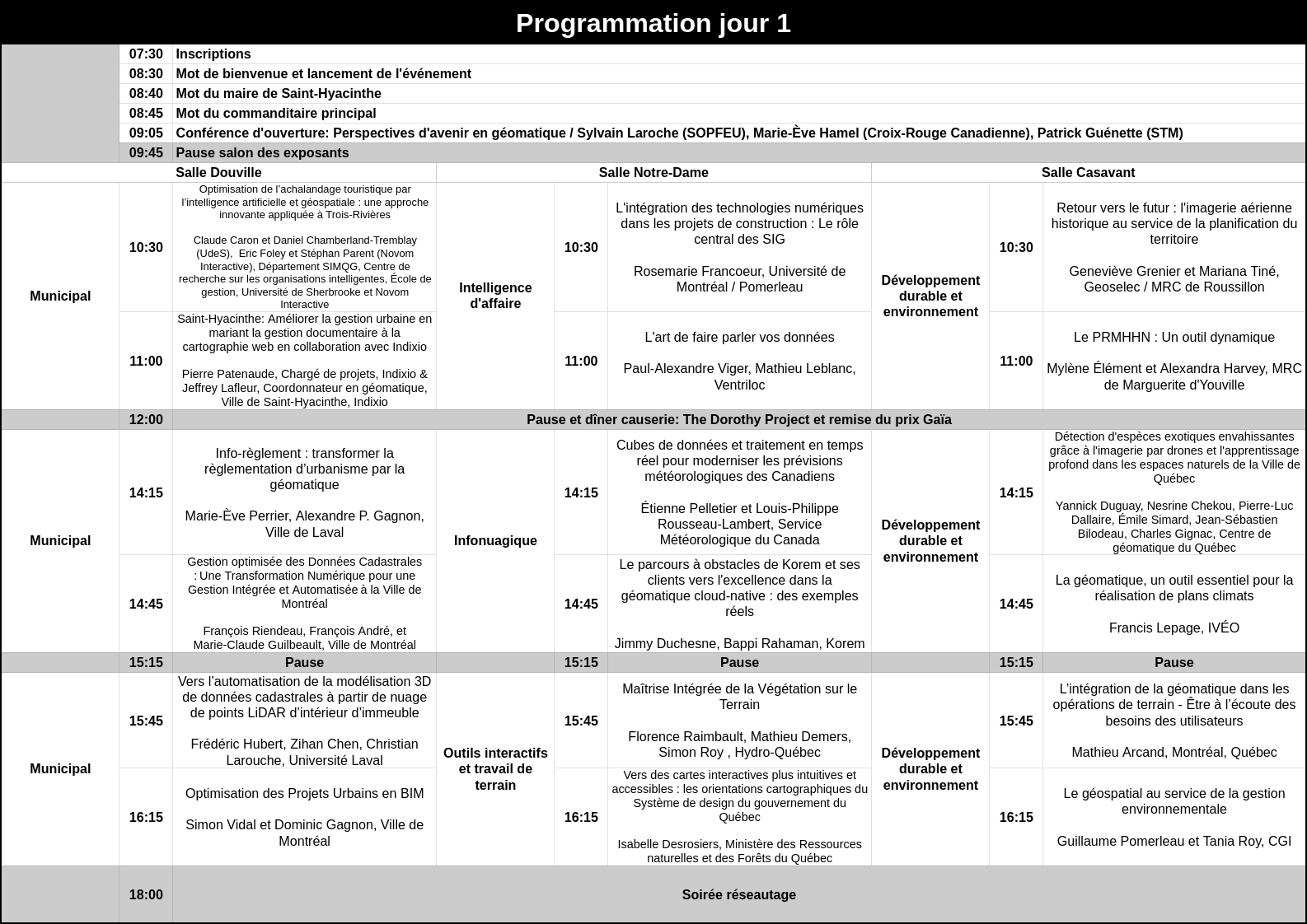
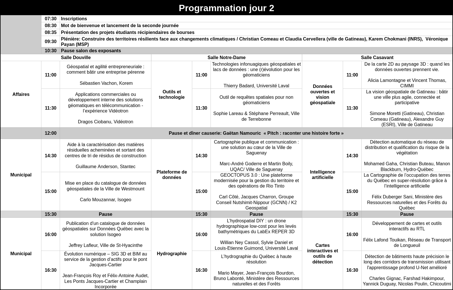
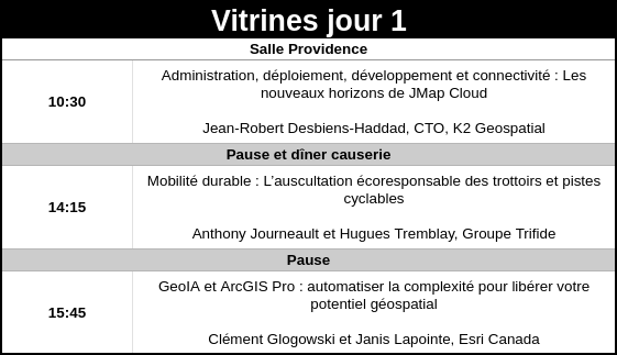
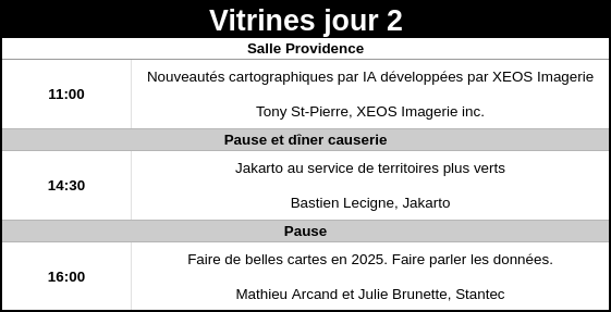
Schedule
Here is the event schedule.
* Preliminary Event Schedule, may be subject to minor adjustments.
Informations
Centre des congrès de Saint-Hyacinthe
1325, rue Daniel-Johnson Ouest
Saint-Hyacinthe, QC J2S 8S4
Reserve your accommodations now.
Event participants can book a room directly online or by contacting the Sheraton Saint-Hyacinthe at 450-250-5555 or 1-833-250-8555. Be sure to mention the group name "ACSG Conference 2025" to receive the discounted rate.
